Behind the Snow: How Our DCMS Tools Captured Baldwin Farms
- DCMS Network Team

- Sep 12, 2025
- 3 min read
Digital Twin | Point Cloud | Revit Model | CAD Plans | Residential Renovation
Turning a brutal winter storm into a seven-day success story.
The Industry Context: Speed Is the New Currency
In high-end residential architecture, time is money. Every decision, from design to permits to construction timelines, has a ripple effect.
72% of remodel projects go over budget due to inaccurate initial measurements.
1 in 3 architects lose 2–3 weeks waiting for as-built documentation before they can even start designing.
In luxury markets like Greenwich, CT, where homes average $4.2M, each day of delay represents thousands of dollars lost in holding costs and client frustration.
Greenwich isn’t just another suburb, it’s one of the wealthiest zip codes in the U.S., where speed and precision are non-negotiable.
The Day the Storm Tried to Stop Us
When our team arrived at Baldwin Farms, a 6,200 sq. ft. contemporary residence, the scene was straight out of a survival documentary.
The driveway vanished under three feet of snow.
Visibility dropped to less than ten feet.
Ice turned every step into a hazard, hiding dangerous areas beneath the surface.
Most teams would have postponed. For our client, stopping wasn’t an option, design needed to start immediately, and permits were on the line.

Capturing Baldwing Farms in extreme conditions, because precision can't wait for better weather
The Challenge: Scanning in Extreme Weather
The storm didn’t just slow us down, it changed the game:
Façades buried in snow, hiding architectural details.
Ice and snow reflections distorting LiDAR readings.
Limited visibility, making exterior coverage both tricky and dangerous.
Our mission was clear: adapt or fail. This is where the strength of DCMS truly shows, technology, strategy, and speed combined.

Point cloud of Baldwin Farms, merging millions of data points into a precise digital twin under extreme coonditions
Two Visits. Seven Days. Zero Delays.
To overcome the storm, we split the project into two critical phases:
Session 1 (During the storm): Interiors + partial exteriors captured.
Session 2 (After snow cleared): Façades and exterior details rescanned for accuracy.
Both datasets were merged into one unified model, ensuring no detail was lost.
📍 On-site time: 10 hours total across two visits.
⏳ Modeling time: 5 days.
🚀 Delivery: From first scan to final deliverables in just 7 days (vs. industry average of 3–4 weeks).
The architect gained two extra weeks to start design and permits, while the client avoided thousands of dollars in delays.

From Point cloud to BIM: a Revit section delivering the accuracy architects need to design with confidence
The DCMS Toolbox: Speed + Precision
Leica Geosystems part of Hexagon #RTC360 – The Speed & Accuracy
Workhorse: 2M points/sec with HDR imagery for millimeter-level accuracy.
Leica Geosystems part of Hexagon #BLK2GO – The Agile Explorer:
Handheld scanning for complex interiors and fast mobility.
Matterport Pro3 – The Storyteller’s
Tool: Immersive 360° digital twins for client visualization and collaboration.
DJI Drone Photogrammetry – The Bird’s-Eye View:
Aerial data capture for façades, roofs, and entire sites.

The DCMS toolbox on site
Deliverables Provided
High-resolution LiDAR Point Cloud
360° Matterport Digital Twin
LOD 300 Revit Model
CAD & PDF Drawings
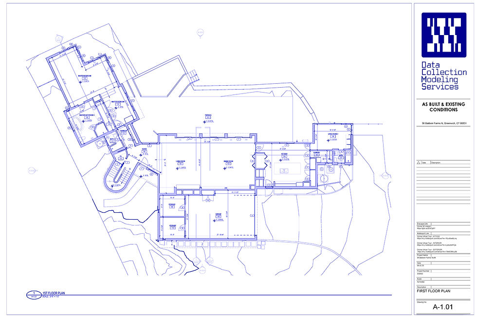
As/built floor plan of Baldwin Farms, pecise documentation for design and permitting
Workflow Stages & Key Tools in Residential Architecture
Concept Design Tool: SketchUp (fast 3D ideation) Why it matters: Quick design iterations and easy visualization for client approval.
Technical Documentation Tool: AutoCAD (industry standard for 2D plans) Why it matters: Accurate drawings for permitting and construction-ready documents.
BIM Coordination Tool: Revit (used in 80% of BIM workflows in the U.S.) Why it matters: Seamless collaboration across design and construction teams.
High-End Visualization Tool: 3ds Max + V-Ray Why it matters: Photorealistic renderings and impactful client presentations.

From scan to render: visualizations that help architects and clients see the design before construction begins
🗣️: "Speed of data delivery is what powers these workflows. At DCMS , our job is to feed these tools faster, so architects can move seamlessly from field reality to design execution, reducing delays and avoiding costly surprises".

Architectural sections extracted from the Revit model, turning reality capture into actionable drawings
Lessons From Behind the Scenes
What Baldwin Farms taught us:
Synergy matters, no single tool solves everything.
Adaptability is a hidden skill, tools are only as powerful as the strategy behind them.
Extreme conditions are opportunities, not excuses to stop.
The Bigger Picture
At DCMS ,we believe that behind every scan, there’s a story. Baldwin Farms wasn’t just about snow, it was proof of how LiDAR, photogrammetry, and digital twins work together to turn chaos into clarity.
🗣️: "From snowstorm to strategy, we transformed a winter nightmare into a foundation for success".
Join the Conversation
Have you ever faced a project where conditions completely changed once you were on-site? How did you adapt? ❄️ Contact us


Comments